Welcome to ECOSTRESS
High Resolution Thermal Remote Sensing: Directional Effects and Applications in Cities and Croplands Abstracts can be submitted on the event website until September 15th, 2026, 23:00 CET
News Flash: ECOSTRESS has now acquired over 660,000 scenes (after In Orbit Checkout)
ECOSTRESS acquires high resolution temperature and emissivity (composition) images of the Earth's surface. These are used for a variety of applications including:
- Determining how much water to put on fields for maximum crop with minimum water use
- Mapping wildfires and volcanic hazards
- Improving urban development and infrastructure
- Discovering critical mineral resources
Plants regulate their temperature by releasing water through tiny pores on their leaves called stomata. If they have sufficient water they can maintain their temperature, but if there is insufficient water, their temperatures rise and this temperature rise can be measured with ECOSTRESS. The images acquired by ECOSTRESS are the most detailed temperature images of the surface ever acquired from space and can be used to measure the temperature of an individual farmers field.
One of the core products that will be produced by ECOSTRESS team is the Evaporative Stress Index (ESI). ESI is a leading drought indicator - it can indicate that plants are stressed and that a drought is likely to occur providing the option for decision makers to take action.
2026 ECOSTRESS Image Competition - Results in a Tie
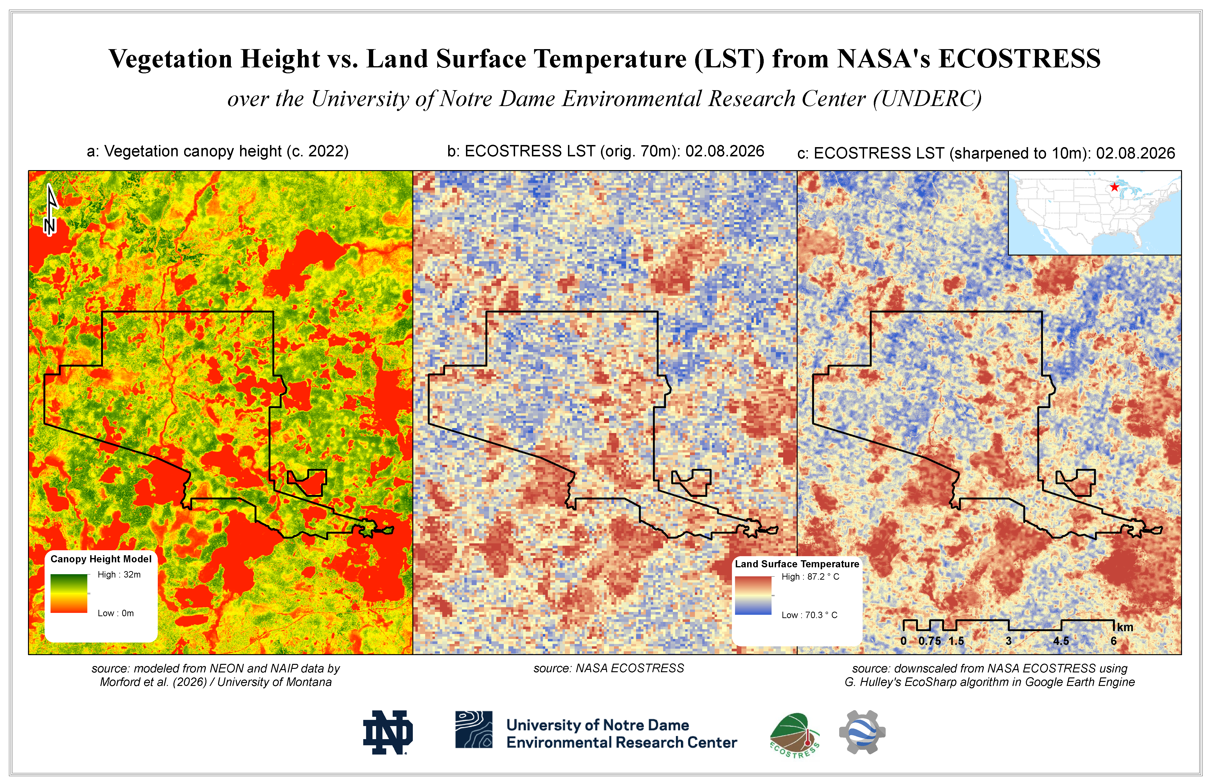
Winner #1
Generated with Google Earth Engine, the map match-up is focused on the University of Notre Dame's Environmental Research Center (UNDERC) National Ecological Observatory Network (NEON) field site, which is located on the border between northern Wisconsin, and Michigan's upper peninsula. What the match-up ultimately shows is how vegetation height (left), derived both from NEON LiDAR data and a modeling effort by the University of Montana compares with land surface temperature (LST) estimates from NASA's ECOSTRESS instrument (center and right). The map on the right is a version of the map in the center, sharpened from 70m to 10m spatial resolution using the EcoSharpalgorithm developed by Dr. Glynn Hulley of NASA's Jet Propulsion Lab. What can be seen is how parts of the UNDERC NEON site with taller trees are generally cooler than areas with shorter vegetation, because of higher evapotranspiration in the former category.
Emil A. Cherrington, Ph.D. (Research Professor, University of Notre Dame Environmental Research Center (UNDERC))
Winner #2
This image is adapted from Fig. 5 of our recently published Nature Communications paper, “NASA’s ECOSTRESS satellite reveals widespread midday depression in ecosystem evapotranspiration.” https://www.nature.com/articles/s41467-026-76873-x. It highlights the diurnal dynamics of evapotranspiration (ET) over center-pivot irrigated agricultural fields in the Nile Delta, Egypt, on August 24, 2018. Using our ECOSTRESS-based ECHO-ET framework, the inset maps show hourly ET from 6:00 to 17:00 local time at 70m spatial resolution. An irrigation event occurred on this day, producing pronounced spatial and temporal variability in water use across individual agricultural fields.
The author chose this image because it illustrates one of the unique strengths of ECOSTRESS: its ability to reveal fine-scale ecosystem water use dynamics at different times of day. The combination of high spatial resolution and diurnal information makes it possible to visualize how irrigation and vegetation water use evolve within a single day—patterns that are difficult to capture with traditional once-daily satellite observations.
Jingyi Bu, Ph.D. (Earth Systems Research Center, Institute for the Study of Earth, Oceans, and Space, University of New Hampshire, Durham)

ECOSTRESS was launched to the International Space Station in 2018. Its primary mission is to identify plants' thresholds for water use and water stress, giving insight into their ability to adapt to a warming climate. However, it has many other science uses including urban heat mitigation, wildfire mapping, water quality, and surface mineralogy.
NASA's Jet Propulsion Laboratory manages the ECOSTRESS mission for the Earth Science Division in the Science Mission Directorate at NASA Headquarters in Washington. ECOSTRESS is an Earth Venture Instrument mission; the program is managed by NASA's Earth System Science Pathfinder program at the agency's Langley Research Center in Hampton, Virginia.